

Map Scale
Any scale can be used for a map, but a few common scales have been settled on for use by most organizations:
- 1:24,000 - primary scaled used by USGS for mapping the United States in topographic form. 1 inch on the map equals 24000 inches in the real world, which is the same as 2,000 feet. This scale is used on the over 54,000 quadrangle maps covering the entire country. They are also called 7.5 minute quadrangles because the area covered by one map is 7.5 minutes of latitude high by 7.5 minutes of longitude wide on paper that is about 29 inches high and 22 inches wide.
- 1:63,360 - 1 inch equals 1 mile
- 1:50,000
- 1:250,000
- 1:1,000,000
The smaller the number on the bottom of the map scale, the more detailed the map will be. A 1:10,000 map will show objects 100 times as large as a 1:100,000 map but will only show 1/100th the land area on the same sized piece of paper.
Here is an example of a Bar Scale found on a map. The scale shows that about 1.25 inches equals 5 miles. The smaller increments to the left of zero are each 1 mile and are used to estimate smaller distances. Notice the scale is 1/250000 - that means 1 inch on the map is equal to 250,000 inches on the real land. (5 miles = 5*5280 feet = 5*5280*12 inches = 316800 inches. 316800 inches / 250000 = 1.27 inches)
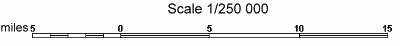
By including a map scale like the image above, if the map is photocopied and reduced in size, the scale can still be used. Otherwise, 1 inch would no longer equal what it should.
Calculating the Map Scale:
Distance on Ground |
== |
5 miles |
= |
316800 inches |
== |
250000 |
Maps are considered
large scale maps
orsmall scale maps
. A large scale map shows greater detail because the scale is a larger fraction than a small scale map.Large scale maps have a scale of 1:50,000 or greater (1:24,000, 1:10,000, ...).
Maps with scales from 1:50,000 to 1:250,000 are considered intermediate.
Small scale maps are those with scales smaller than 1:250,000. A map of the world that fits on two pages of letter sized paper would be very small scale with a scale of around 1:100,000,000.
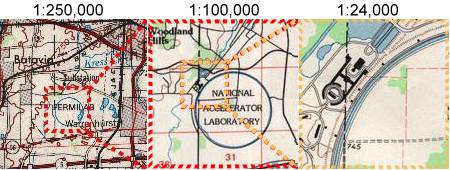
Here are 3 views of the same location on maps with different scales:
 |
 Why are maps like fish?
They both have scales! |
| Search Google News for more 'Lost Hiker' news items. |

Comments:
Feb 15, 2018 - K
Ask a Question
More Map and Compass Resources at CompassDude.com
Recent Comments