

Triangulation Exercise
Another Triangulation Exercise
If you came directly to this page from some other site, you should start on the home page or at least read the Triangulation Page first.
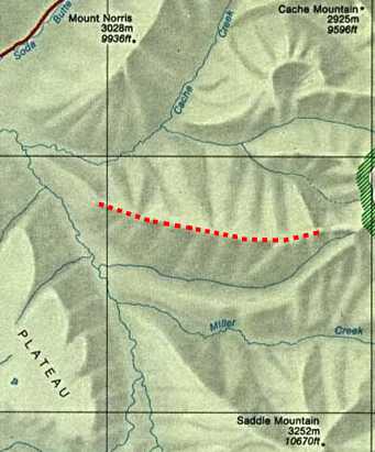
You have just climbed the highlighted ridge after fishing in Miller Creek. You do not know where along the ridge you are standing, but you can see 3 mountains off in the distance north and south.
You take bearings to the mountains and get:
- 333 degrees to Mt. Norris
- 33 degrees to Cache Mountain
- 161 degrees to Saddle Mountain
To simulate taking each of these bearings, turn your compass dial until that bearing is at the index pointer. Then, turn the compass until RED is in the Shed and the direction-of-travel arrow will be pointing along that bearing.
Transfer your bearings to the map and find out where they intersect. If you oriented your map, took correct bearings, and transferred them accurately, your map should look close to:
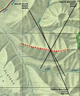
Notice that two bearings that are nearly opposite each other do not do a good job of triangulating. It is important to get another landmark at approximately right angles with one of your landmarks.
Mount Norris and Saddle Mountain have a wide possible intersection but Mount Norris and Cache Mountain have a much smaller intersection area.
| Search Google News for more 'Lost Hiker' news items. |
| 18 May 2026 - |
| 18 May 2026 - Lost hiker rescued in Red River Gorge over the weekend |
| 18 May 2026 - |
| 10 Feb 2026 - How an Ultrarunner Saved a Lost Hiker's Life |
| 14 May 2026 - Tennessee Guardsmen airlift lost hiker from National Forest |
| 13 May 2026 - Search underway for missing 80 |

More Map and Compass Resources at CompassDude.com
Recent Comments