

Contour Line Quiz
Contour Map Quiz
Match the contour line drawing in the PHOTO column with the corresponding contour line image in the TOPO column. See the bottom of the page for answers to contour map quiz.
Hint #1: The Arrow in the TOPO images point downhill.
Hint #2: Don't get frustrated with the answers. A couple are very similar.
PHOTO   |
TOPO   |
Answers: |
Answers will be shown here.
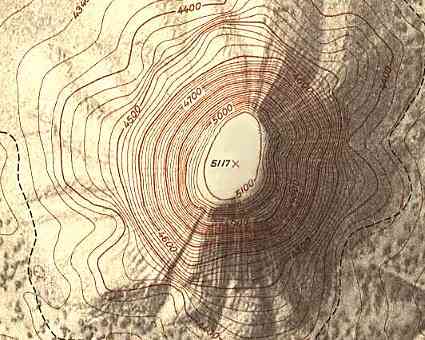
The contour map below uses a 1:4,800 scale. Notice the shaded relief to improve the map. Using what you've learned about contour lines and topographic maps, figure out which photo goes with the map.
Answer: |
Answer will be shown here.
Next: Using Map and Compass
 What do you get when you cross a cowboy and a mapmaker?
A cow-tographer! |
|
A B C D E F G H I J K L M |
3 - gradual, consistent slope 5 (or 8) - draw or valley with stream 13 (or 4) - cliff face 12 - hill with ridge 9 - spurs on a mountainside 10 - a depression 4 (or 13) 7 - Steeper slope high, gradual low 1 - consistent slope 2 - gradual slope high, steeper low 11 - a saddle between two hills 8 (or 5) 6 - simple round hill |
|
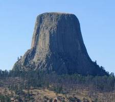
The contour lines are very close together, indicating an extremely steep slope that rises from 4500 feet to 5100 feet - that is about 2 football fields standing on end. A perfect bulls-eye shape is created, indicating a circular mountain. The open center circle inside the 5100 contour line indicates that the top of the mountain is a flat plateau. This topgraphic map is of Devil's Tower which is the photo in the lower left. |
| Search Google News for more 'Lost Hiker' news items. |
| 24 Jul 2026 - Experience |
| 20 Jul 2026 - Lost Hiker Mt. Willard |
| 23 Jul 2026 - Search continues for missing 77 |
| 22 Jul 2026 - Remains of Hiker Bill Ott Missing Since 2012 Found in Grand Canyon |
| 21 Jul 2026 - Just a moment... |
| 21 Jul 2026 - Hiker Rescued After Getting Lost at Montaña de Oro State Park |

Comments:
Oct 16, 2015 - Amy Leslie
On behalf of the Boy Scouts of America (BSA), I am expressing
interest in using the contour quiz graphics in our new edition
of the Boy Scouts Handbook.
We are working with subject experts and BSA volunteers to include the most relevant, interesting information and visuals available to increase a Scout's engagement with this important skill. It is within this context the BSA would like to include your quiz graphics in our new edition of the handbook.
Thank you in advance for granting this permission. I am available to answer any questions you may have. If you are not authorized to grant any or all of these rights, I would appreciate your referral to the correct person in your organization.
Regards,
Amy Leslie
Boy Scouts of America
1325 West Walnut Hill Lane
Irving, Texas 75038
Sep 21, 2017 - Meghan SauerWe are working with subject experts and BSA volunteers to include the most relevant, interesting information and visuals available to increase a Scout's engagement with this important skill. It is within this context the BSA would like to include your quiz graphics in our new edition of the handbook.
Thank you in advance for granting this permission. I am available to answer any questions you may have. If you are not authorized to grant any or all of these rights, I would appreciate your referral to the correct person in your organization.
Regards,
Amy Leslie
Boy Scouts of America
1325 West Walnut Hill Lane
Irving, Texas 75038
Thank you for posting this. I don't have enough computers for my
students to access your site, but I'd like to use your work on
topo/contour maps unit and properly credit you.
Oct 30, 2017 - Trevor WilliamsHow are you supposed to draw a line?
Oct 30, 2017 - Compass Dude@Trevor - The instructions say to "match" images from each column -
there are other ways to match without drawing a line. But, if you
really want to, go ahead and use a magic marker on your
computer/tablet/phone/... screen to draw a line. Or, print the
page and draw lines.
Oct 31, 2018 - BreaunaI liked this. It really helped me to understand some things
were talking about in science.
Ask a Question
More Map and Compass Resources at CompassDude.com
Recent Comments