

Compass Declination
Man, you thought latitude and longitude was rough, just check out this declination stuff!
I'm sorry to be the one to tell you that your compass doesn't work quite right. It doesn't really point to the north pole or the south pole.
Not only that, next year it will point someplace different than it does this year! And, someday it may be completely backwards!
Two North Poles
There are actually two north poles - the Geographic north pole which is the axis around which the earth spins, and the Magnetic north pole which is where compass needles point.
Why are there two different poles? Good question!
The magnetic north and south poles are the ends of the magnetic field around the earth. The magnetic field is created by magnetic elements in the earth's fluid outer core and this molten rock does not align perfectly with the axis around which the earth spins.
There are actually many different sources of magnetic activity around and in the world. All those influencing factors combine to create the north and south attractions at each spot on the globe. The actual strength and direction of 'north' is slightly different everywhere, but it is generally towards the 'top' of the planet.
Magnetic Declination
The difference between the north geographic pole and the north magnetic pole is called magnetic declination or usually just declination.
Depending on where you are on the earth, the angle of declination will be different - from some locations, the geographic and magnetic poles are aligned so declination is minimal, but from other spots, the angle between the two poles is pretty big.
Here is a map of the angles of declination for the U.S. as of 2010:
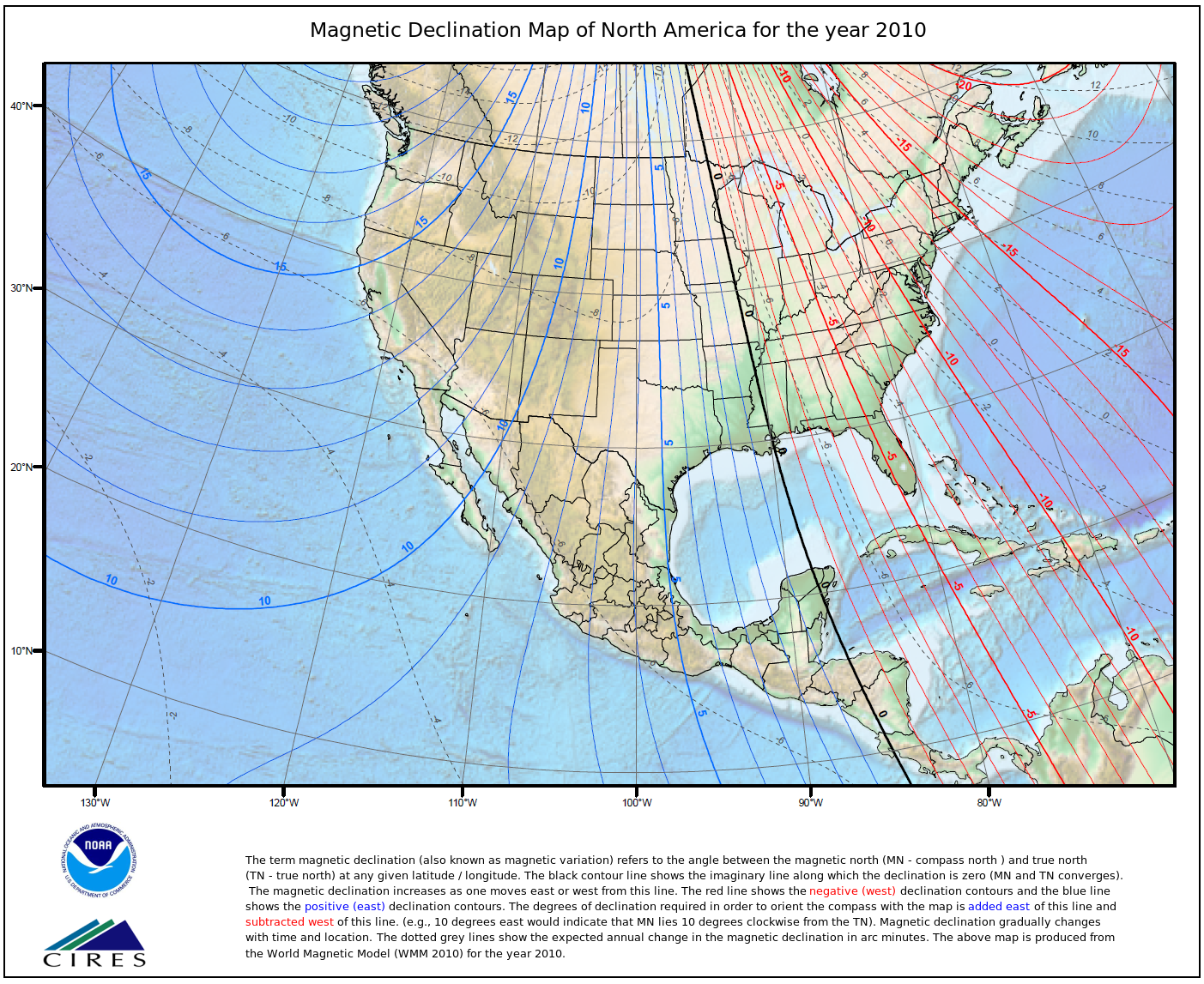
(click for large image)
Notice the black line with 0 on it running down the Mississippi river? Along this particular line, both the geographic and magnetic north poles are in alignment so there is no declination. If you move East of this line, the magnetic north pole will pull your compass needle further and further to the West of geographic north - the angle of compass declination is West Declination. Moving west of the Mississippi river will pull your compass needle further and further to the East.
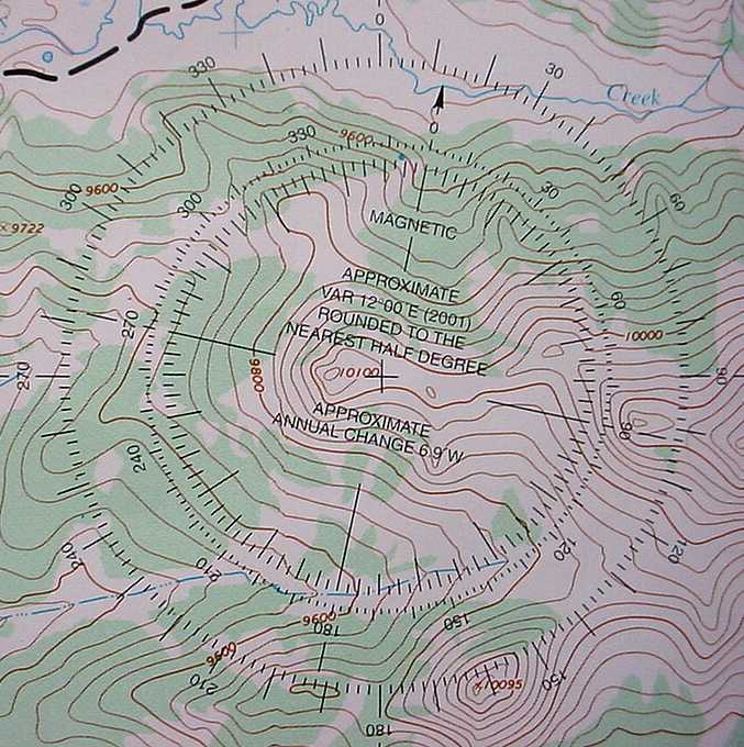
This makes it a bit more challenging to find your way because your compass tells you North is a different direction, depending on where you are. Topographic maps used for navigating should have the declination printed on them like this example. This declination is for an area in the Bighorn Mountains in Wyoming where the declination is 12 degrees East in 2001, when the map was made.
(Click the image for a bigger version)
It also says that the declination is changing 6.9 minutes West each year. Using this old map, the declination would be about 11 degrees East in 2010 - about 1 degree less than the map has printed.
Unfortunately, the rate of declination change changes over time. When the map was printed, the rate of change was 6.9 minutes West each year. But, it has now sped up to 9 minutes West each year. This has been changing every year since the map was printed so the current declination for this area is 10 degrees 41 minutes East. That is already a larger change than what we would expect for 2010, based on the map's information.
Does it make good sense to use a map's declination information if that map is more than a couple years old? NO, you should use recently published maps or know the current declination for the area and use that information for your navigation.
There are a few ways to solve this extra challenge of finding true north - either changing your compass or using math in your head.
Adjust Your Compass
 On many compasses, you are able to adjust the declination by twisting a ring, using a screw, or some other method of changing where the orienting arrow sits in relation to the ring.
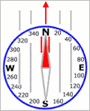
If you used a compass set with 0 degrees declination in Wyoming where the declination is 12 degrees East, the compass would tell you that you're heading North when you're actually heading 12 degrees East of North.
You'd quickly wind up off course and lost.
 By adjusting the compass to match the declination on our map, the orienting arrow now appears to be offcenter from North, which is how it should be.
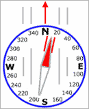
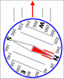
Now, when you put RED in the SHED (needle inside orienting arrow), the North indicated at the index pointer is true north and matches your map.
You can continue to check your location and chart your course correctly.
Whenever you stop and check your heading or take a bearing on a distant object, the degrees read on the dial will be the actual true degrees. The only thing that looks a bit odd is that the north end of the compass needle does not point directly at the N when you are heading due North.
Using Your Head
 If you have a compass with no declination adjustment or you just like math, then you can do the declination calculations in your head.
If you are in Wyoming with a 12 degree East declination, add 12 degrees to the heading you read on your compass dial to determine your true heading.
In this example, the reading is 250 degrees.
But, you are actually facing 262 degrees.
So, to actually head 250 degrees, you need to get a reading of 238 degrees and then you're heading the right way.
Inclination
 Inclination is the angle of pull down toward the earth that the magnetic field exerts on a compass needle. At the north magnetic pole, the north end of the needle is pulled straight down toward earth.
 Using your brilliant mind, you probably figured that a compass doesn't do much good if it is pointing straight down. And, actually, for hundreds of miles around the magnetic poles, compasses are worthless. For even more hundreds of miles around that, compasses can be erratic.
So, if you are planning an arctic or antarctic expedition, don't count on your Silva or Brunton for getting you there and back.
Not only that, but there are southern hemisphere and northern hemisphere compasses.
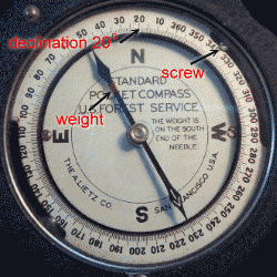
I have an old Forest Service compass that you can see here. It has a weight on the southern end to offset the inclination pull in the northern hemisphere. If this compass is taken to the southern hemisphere, the weight would cause it to drag and not balance properly.
You might also notice the two declination adjustment screws and the fact that it is currently set for about 20 degrees East declination. And, you should note that this is not a good compass for mountaineering for many reasons.
The Drifting Poles
 Back to the magnetic north and south poles - remember I said they were caused by the earth's molten outer core? Well, things are always shifting and churning down there. So, as the liquid rock moves, so does the magnetic field.
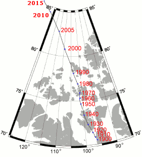
This map shows how the north magnetic pole has shifted over the past century. Notice that it has picked up speed and has moved more in the last 15 years than in the 50 years before that, now moving about 25 miles per year on its way out of Canada and heading to Russia.
So, how does this effect compass use and navigation? Well, if you follow your compass north this year, you will be drawn towards a different place than 15 years ago. Declinations are constantly changing and that means what is written on a map you buy this year will be incorrect next year. The difference depends on where the north pole moves to and what your current declination is.
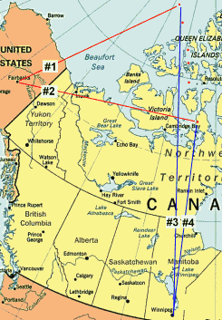 For example, if you pointed north from Fairbanks, Alaska in 2006, you would follow Line #1.
100 years ago, you would have followed Line #2 - huge difference!
From other places, such as Winnipeg, Manitoba, Line #3 in 2006 and Line #4 100 years ago are nearly the same.
It's interesting to compute the declination for your location.
This will pop up a new window.
In the new window, enter your Zip Code and click the "Get Location" button. Then, click the [Calculate] button to find the declination for today, or enter any date and find out how the declination will change over time.
These moving magnetic poles continually effect navigation. It's more serious for airplanes and ships, but even for hikers and backpackers, it causes problems. Using a 10 or 15 year old map is a bad idea since the declinations are no longer accurate.
If the north pole movement continues at its present speed, it moves 250 miles every 10 years, but it has been speeding up so no one knows what the next 10 or 20 years hold in store. Historically, the magnetic field of the earth has churned over and reversed and some scientists say we are well overdue for such a reversal.
See current and historic declination for the whole world - notice the south magnetic pole
 Why didn't True North marry Magnetic North?
She didn't like his bearing and he was just a drifter. |
| Search Google News for more 'Lost Hiker' news items. |
| 09 Jul 2026 - Lost Hiker on Moat Mountain Trail |
| 09 Jul 2026 - Forest Rangers locate lost hiker in Western Adirondacks |
| 04 Jul 2026 - Site Not Available |
| 06 Jul 2026 - Hiker visiting from Brazil rescued from Mount Washington after getting lost for over 16 hours |
| 09 Jul 2026 - 2 Separate Hikers Rescued On New Hampshire’s Moat Mountain Trail |
| 08 Jul 2026 - Lost Hiker Found in Fulton Chain Wild Forest in Herkimer County |

Comments:
Dec 15, 2015 - Annie
In that part of the earth, using a GPS or monitoring sun movement would be more useful than a compass.
I think this is incorrect. If you subtract 12� from 238, you would get 226.
In regards to declination - does that mean that when orientating a map (finding north in relation to your position on the map) that we should use the magnetic declination reading as our North point ? For example, I live in New Zealand and we have a general declination of 20 degrees east. Does that mean that when I orientate the map, I make sure that the magnetic needle stays inside the orientating arrow which points to magnetic north and not use grid north?
Thank you for your time,
Dan
If your compass does not have the ability to adjust, then lay it on the map in line with the grid lines and rotate the map until the north needle points to 340 degrees, which is 20 degrees west of North, matching your local declination. Then, map north and geographic north are oriented.
CDMVTAE
Compass Deviation Magnetic Variation True Add Easterly
When going to the right on the line, add Easterly, as:
When going from Compass heading to Magnetic heading, add Easterly deviation.
When going from Magnetic heading to True heading, add Easterly variation.
When going to the left on the line, add Westerly.
I am trying to figure out what degrees offset a compass for my area.
What would be the bearing of that line today ?
How do I calculate that?
You can see the magnetic declination for a location and a given year. The new bearing would be changed by the difference in the declination between 1972 and 2017.
On ease! Now soldiers, if you want to dig into the subject deeper, get Ph.D. from geology, astronomy, meteorology, cartography, history of Earth, polar reversals, magnetism and most important - a little common sense and imagination.
If to the left add, if to he right subtract. Ex: if in NH your
declination is ~14 degrees, so after adjustment your red
indicator should be on 14 degrees. Carry on.
I’ve never seen a reference to this method but it makes sense. Polaris is true north and varies less than 1 degree. What do you think?
It would be interesting to hear how it works, if you give it a try.
I just wanted to thank you for the great information. I have known about Declination for a long time as I took some flying lessons when I was young.
Several years ago I got a weather station and mounted it on my roof. My house is surrounded with trees so I can't see the street. I know from maps that the streets in Anchorage are oriented N/S but my house is not sitting on the lot N/S. So a few years ago I bought a compass. It always pointed to me anyway too far to the right NNE. I suspected it was the Declination but never knew how far it was. your link to NOAA has a calculator and with my coordinates it's 15.5 degrees East. So I got out the compass and that is just about how far off I figured the compass was. It does have a turning ring so it is now set and I know the answer to a long time question.
Thanks
Great work and information both from you and the numerous individuals commenting here ! Thank You all for the education !
Just one question on the compass pointing down the closer one gets to the magnetic North pole. Are models currently produced that offset the center axis pitch dependent upon what pole one may find themselves at ? In short do i need a "North Pole " and a "South pole" compass or can i make due with one ? Thanks in advance for you response. Much appreciated !
east is positive and so you have to subtract the declination to be in North direction, if west you have to add the declination to be on course, that is how i understand it.
If you followed a 240 degree heading indicated on your compass, you would actually be heading 225 degrees. To compensate, you should follow a heading of 255 degrees indicated on your compass to actually head 240 degrees.
As you can see on the USA map above, if you know roughly where you are and know that declination gets worse the farther you are from the Mississippi River, you can adjust your reading a bit.
But, I would have no idea what the declination was if I was dropped off in the wilderness of Mongolia for example. I'd just use my compass to "get close".
You can always find some land feature that runs straight a fair distance. A road, power line, edge of a large field, etc. Measure the bearing on the map as if intending to walk in that direction.
Then measure the same bearing with the compass. The difference in degrees, between map bearing & compass measured bearing. Would be the mag. declination. At least as accurately as you can read it. [many compasses are only accurate to about 2.5˚, some higher end compasses to 1˚ or 0.5˚, but with a resolution of only 2˚]
Example: If on the map a road runs to the NE at 45˚, but with the compass the road bearing (azimuth) is 55˚, your mag. declination would be 10˚ West. If the compass shows the road runs straight on a heading of 38˚, then your local mag. declination is 7˚ East.
You can determine your local mag. declination yourself as accurately as needed for recreational navigation.
If mag. declination is West, turn the compass degree dial CCW.
If mag. declination is East, turn the compass degree dial, CW. Examples: If 8˚ West, turn the dial 8˚ CCW. IF 12˚ East, turn the dial 12˚ CW.
I created an acronym and phrase to help me remember the correct adjustment:
WAvES - [West Add v East Subtract].
The "v" symbolizes the mag. declination diagram.
The phrase:
"The Map WAvES to the Compass, and the Compass WAvES back(wards) to the Map".
Meaning - when you take a compass measured bearing back to the map, to get the correct bearing to use on the map. You do the math backwards. West add becomes west subtract. East subtract, becomes east add.
For mag. decl. = 9˚west. If the compass azimuth = 279˚. On the map you would use a bearing of 270˚. That's why west mag.declination is given as X negative degrees online.
So, if it was me, I'd just use a free mapping app on my cellphone, go to the first marker and save a GPS waypoint on my phone, go to the next marker and repeat. Then, have the app show a line between the two markers. As I walked back to the first marker, keep the dot indicating me right on the line and mark the boundary as I went to get the approximate line.
Ask a Question
More Map and Compass Resources at CompassDude.com
Recent Comments